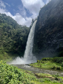
From Condor Machay Falls to Hacienda Santa Rita
Pincha aquí para la versión en castellano
On Sunday, April 27, we officially began the acclimatization hikes to
ascend Cotopaxi. At 9 am, Pablo, the guide from Andeanface, and Patricio (a
driver) arrived to pick us up in a passenger van. As usual, we were not ready
on time, and we ended up leaving around 9:30, heading towards a point in the ‘La
Caldera’ sector from where we would start walking till our destination of the
day: Hacienda Santa Rita (about a 5-hour walk). Tete, Ximena, Daniel, and the
kids: Tomás and Joaquín, would join us in the afternoon in Santa Rita.
The van arrived at the parking lot of the Condor Machay Ecological Reserve around 11 am. Ciro was already there waiting for us with the food we should bring in our backpacks for that day's hike. The plan was to transfer our bulky items from the passenger van to the Andeanface’s Toyota Ciro was driving, and only carry light backpacks with sandwiches and snacks for the day. Patricio would return to Quito in the empty van, Ciro would drive the Toyota with the bags to the Hacienda Santa Rita, and we would catch up with him there, later at the end of this first walk.
The hike took place along the banks of the Pita River, within a dense forest, despite being over 3,000 meters above sea level. At one o'clock in the afternoon, we arrived at the Cóndor Machay waterfall, after crossing the river 11 times through the same number of bridges made of iron and wooden planks. We passed several waterfalls before reaching Condor Machay, which is a majestic fall of about 80 meters high. The water crashes onto a rock at the bottom, turning it into mist, dew, and raindrops that wet everything around. We ate our sandwiches there, with peanuts, plantains, and Oreos, getting wet by the spray of the waterfall. After finishing, we began the return to the parking lot, then headed out to the road to cover the distance left to reach Hacienda Santa Rita.
We arrived at the camp at 5 pm. Ciro welcomed us with the tents already
set up and the kitchen installed. Ximena, Daniel, Tete, and the kids had also
arrived. The first two arrived earlier because Tete and her grandkids were left
5 kilometers before reaching the Hacienda to walk the final distance. They
walked in the rain, which was curious because we did not, and in a nearby
village, they saw some young people learning to bullfight with a sheep (we also
missed this).
Fact Sheet:
|
Distance: |
Parking to Condor Machay Fall: 3.81 Km Parking to Santa Rita: 4.52 km Total Distance: 12.14 km |
|
Altitude Gain: |
+100m |
|
Time: |
6 h |
|
Difficulty: |
Low |


Comments